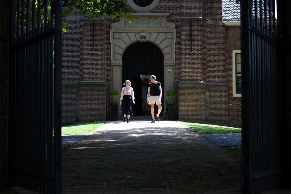
Village walk Middenbeemster
At the turn of the 16th/17th century, the expanding Beemster Lake began to increasingly threaten the surrounding residential areas. What once began as a small meandering river (the Bamestra) through the swampy peatland took the form of a substantial inland waterway.
Wealthy Amsterdam merchants see an opportunity to invest money in their own country during this politically calm period. They join forces with some representatives of the powerful political elite from The Hague in 1607. Within weeks, they get permission to dike and reclaim the Beemster Lake. Land was also a good investment at the time in connection with food production for the rapidly growing cities. Partly because of the size of the lake, reclamation is a huge challenge. By 1610, the work is almost complete. However, a violent storm causes the advancing Zuiderzee water to pound against the fledgling Beemster dyke, which fails in several places.
Some entrepreneurs sell their stock...
Wealthy Amsterdam merchants see an opportunity to invest money in their own country during this politically calm period. They join forces with some representatives of the powerful political elite from The Hague in 1607. Within weeks, they get permission to dike and reclaim the Beemster Lake. Land was also a good investment at the time in connection with food production for the rapidly growing cities. Partly because of the size of the lake, reclamation is a huge challenge. By 1610, the work is almost complete. However, a violent storm caused the advancing Zuiderzee water to smash against the fledgling Beemster dyke, which gave way in several places.
Some entrepreneurs sell their share in the reclamation at a considerable loss. Others, more capital powerful ones continue the business with additional investments. Two years later, things work out. Then work can begin on the special infra structure. A grid of straight roads and ditches ensure good drainage and efficient geometric plot division.
On 30 July 1612, at Slot Purmersteijn in Purmerend, the plots are distributed to the investors. The dryers also marked out five church villages in the grid. With the main village at the core: Middel Beemster. This rational layout coupled with the resulting classical beauty of the area prompted Unesco to designate the reclamation area as a Unesco World Heritage Site in 1999. Three years earlier, the 'Stelling van Amsterdam', with a number of forts located in the Beemster, also received this predicate.
You are going to see this
The neighbourhood | village walk
The walk along 'de Buurt', the old name for Middenbeemster, starts at the foot of the Keyserkerk. The ditches and fences on the squares still bear witness to the cattle markets that were held here.
The neighbourhood | village walk
The walk along 'de Buurt', the old name for Middenbeemster, starts at the foot of the Keyserkerk. The ditches and fences on the squares still bear witness to the cattle markets that were held here.
The Keyserkerk, named after the famous Amsterdam city architect Hendrik de Keyser, was built between 1618 and 1623. Many rich merchants built country houses in the new reclamation area. Naturally, when they are here in the summer, they want to be able to attend churches 'on a stand'. As the tower soon began to give way, the ground remaining boggy, two 'rooms' were later built against it.
On the westzijde is an extension designed by architect Jan Henket in 2012. This ensures that the church also has a socio-cultural function. In the summer months, the church can be visited on Sunday afternoons. From the church gate, you also have a good view of what is now theatre Onder de Linden. Built in 1839 as a school building. After the school moved in 1883, it housed the fire station.
A striking feature is the hose tower. This is where the wet hoses were hung to prevent rot. Before, they were hung out in the church tower. On the south side of the church, a workers' neighbourhood arose shortly after reclamation: the Kerkebuurt. Only a few houses still stand there.
The Kosterij | Village walk
On the corner is 'the Kosterij'.
The Kosterij | Village walk
On the corner is 'the Kosterij'.
Now a lunchroom cum food shop. Formerly the sexton's living/working place. But also the place of education. In fact, the sexton is also cantor and schoolmaster. Including the creatively talented Fabritius family. Son Carel, for instance, became a pupil of Rembrandt. He is best known for 'The Little Putter'. His bust stands in the sexton's garden. The present building dates from the second half of the 19th century.
Presbytery and villa Middelwijck | village walk
At the sexton's neighbours: the former vicarage (= residence of the vicar). Now 'Betje Wolff museum'.
Presbytery and villa Middelwijck | Village walk
At the sexton's neighbours: the former vicarage (= residence of the vicar). Now 'Betje Wolff museum'.
Reverend Wolff lived here in the mid-eighteenth century with his second and much younger wife Elizabeth ('Betje') Bekker. Betje Wolff and dearest friend Aagje Deken would later become nationally known writers. A visit to the museum (residential culture) is recommended.
With your back to the rectory, you have a view of three stately mansions on the other side of the Middenweg. On the far right is villa Middelwijck. Built as a head teacher's residence. In front of the school located behind it (later in the route you pass the school). Later it becomes the official residence of the mayor and seat of the Beemster Water Board. These three houses were all built in the last quarter of the nineteenth century. Shortly after the reclamation, a sizeable country estate called Middelwijck already stood at this location.
Villa Schoonoord | Village walk
Built in 1883 by notary van Beek.
Villa Schoonoord | Village walk
Built in 1883 by notary van Beek.
The building had a banking function for many years and is now a chic bridal shop.
Westerhem | village walk
Cross the Middenweg at Villa Schoonoord (zebra crossing). Enter the 'Kerkhoflaan'.
Westerhem | village walk
Cross the Middenweg at Villa Schoonoord (zebra crossing). Enter the 'Kerkhoflaan'.
To the left of the road is the mansion Westerhem. This now houses the Visitor Centre Westerhem ('Visit Beemster'). The front house and the stolp farmhouse behind it were built by order of Mayor Scheringa. The stolp now houses the Westerhem agricultural museum. A visit to the Visitors' Centre and the agricultural museum is highly recommended. As the name suggests, the avenue leads to the Churchyard. Or more accurately, the New Cemetery. Established shortly after the mid-nineteenth century. As required by law, the cemetery is laid out well outside the built-up area. On a mound. After all, the Beemster lies several metres below sea level.
Walk a short distance along the Kerkhof avenue and turn right at a striking white building into Leeghwaterstraat.
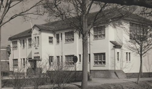
Uloschool | Village walk
The white building, now living and working space for artists, was built in 1922 as a uloschool.
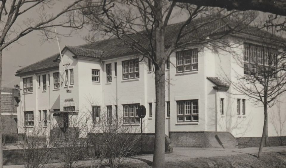
Uloschool | Village walk
The white building, now living and working space for artists, was built in 1922 as a uloschool.
From all over the region (from de Woude to Purmerend), pupils come here. It is now popularly known as 'the white mavo'.
Jan Adriaanszoon (Leeghwater) | Village walk
Walk down Leeghwaterstraat. The workers' houses here were built in phases around World War I.
Jan Adriaanszoon (Leeghwater) | Village walk
Walk down Leeghwaterstraat. The workers' houses here were built in phases around World War I.
Because there was a shortage of affordable rental housing. At the urging of the municipal council, the initiators united to form 'Woningbouwvereniging Goed Wonen'. The street is named after the Rijper mill builder and hydraulic engineer 'Jan Adriaenszoon'. He would later add the name 'Leeghwater'. Initially, the Council wanted to name the street after the first Dijkgraaf (= head of the dyke administration). Not knowing who this is, it becomes Leeghwaterstraat. Fortunately, because the first Dijkgraaf, Lambert Wijngaertsz. van Vollenhoven, obtained this position by submitting forged title deeds to land under the Beemster Lake. In July 1609, the forgery is discovered. In vain, an attempt was made to collar him at Purmersteijn Castle (where the dyke authority initially had its seat). The bird appears to have flown by then!
Post Office/Secretariat | Village walk
Halfway down Leeghwaterstraat, an imposing castle-like building stands on the left.
Post Office/Secretariat | Village Walk
Halfway down Leeghwaterstraat, an imposing castle-like building stands on the left.
The Main Post Office from 1917. It only held this status for a short time. A main post office of this size turned out to be a bit too spacious. Then came the Secretariat (= civil servant's
officials of the municipality) moved in.
Dairy factory Bamestra | village walk
Walk halfway down Leeghwaterstraat into Schoolstraat (right).
Dairy factory Bamestra | village walk
Walk halfway down Leeghwaterstraat into Schoolstraat (right).
The school, built in 1883, can still be recognised on the right-hand side. With Middelwijck at the head again. In front of the Head of School. On the other side of the street, now an apartment complex, dairy factory Bamestra was built at the end of the nineteenth century. Initially, cheese and butter were made on the farm. Often a job for the farmer's wife. Around the turn of the century, farmers united in cooperatives and dairy factories were built in numerous places in the Beemster
built. Like the Bamestra. Named after the small river before reclamation.
Return to Leeghwaterstraat and continue the route. At Leeghwaterstraat 2 a 'foundation stone' of Goed Wonen.
't Landje | village walk
At the end of Leeghwaterstraat, you will see a prominent grassy field on the right.
't Landje | village walk
At the end of Leeghwaterstraat, you will see a prominent grassy field on the right.
Surrounded by cute little houses. This former bleaching field (for bleaching laundry) and event site (Beemster fair) is called ''t Landje'.
The Heerenhuis | Village walk
Turn left onto the Rijperweg. Turn left into 'het Heerenhuis' (Brasa).
Het Heerenhuis | Village walk
Turn left onto the Rijperweg. Turn left into 'het Heerenhuis' (Brasa).
The story goes that Princes Maurice and Frederik Hendrik were welcomed here at the end of July 1612. Unfortunately, Jan Adriaansz Leeghwater is the only primary source for this story. In any case, the fact is
that for centuries this building combined two functions: catering (inn) and place where the 'lords governors' could meet. The former council and wedding hall (above) still has its own entrance with stately double door (right). J.A. Leeghwater flaunts himself in front of the building. As a mill builder and hydraulic engineer, he certainly played a significant role during the reclamation. But not the leading role he gave himself (and later adopted by others).
Amsterdam School houses | Village walk
Stay on this side of the Rijperweg. The south side of the Rijperweg became the 'rich side' shortly after reclamation.
Amsterdam School houses | Village walk
Stay on this side of the Rijperweg. The south side of the Rijperweg became the 'rich side' shortly after reclamation.
The dignitaries wanted to live together and next to the Heerenhuis. Later, it became more of a mix of middle-class houses (resting farmers) and small middle-classes. Also a striking mix of styles. Right next to Brasa were three houses in the Amsterdam School style. Offering handsome housing helped recruit suitable teachers and other civil servants. An incomplete list of tradesmen on this side of the road in the first half of the 20th century:
a printer/publisher (including publisher of 'De Drie Meren'), a bookshop, a carpenter, a hoof and coarse forge, a paint shop, a petrol station and a post office. Anyone who wanted to could start a shop or business.
Walk up to the white building right opposite the supermarket: the former post office.
Post office | Village walk
How do things go. The Kleiterp family lived in this building.
Post office | Village walk
How do things go. The Kleiterp family lived in this building.
The man of the house perished. In 1941, the widow offered to donate part of her house as a post office. Provided she is allowed to become a post office keeper herself. Things could be that simple. The post office entrance (side) is still visible.
The Island
Diagonally opposite the white post office was another working-class neighbourhood: 'the Island'.
't Eiland
Diagonally opposite the white post office was another working-class neighbourhood: 'the Island'.
Surrounded by ditches and fairly isolated to outsiders. An enclave entirely on the outside of the village. With small houses, mostly large families and communal 'plees'. Demolished in the mid-20th century, it now provides additional parking for the supermarket.
Cross the Rijperweg. Lots of middle-class houses on this side of Rijperweg too. I would mention: a house and carriage painter, a greengrocer, an oilman, a draper, a small grocer, two butchers, a coachbuilder, a petrol pump, (there were several on the Rijperweg) a blacksmith, a transporter, a supermarket (Spar) cum tobacconist cum barber shop. For all your daily business you could go to your village.
On the north side of Rijperweg, walk back towards the Keyser church. Stop at the Santhé bakery.
Stationskoffiehuis 'het Bonte Paard' | Village walk
On the spot where Raadhuisstraat now begins (next to the current bakery) there was 'hospitality industry' for centuries.
Stationskoffiehuis 'het Bonte Paard' | Dorpswandeling
On the spot where Raadhuisstraat now begins (next to the current bakery) there was 'hospitality industry' for centuries.
A combination of inn, coffee house, café, livery stable and room hire. Shortly after World War II, the station coffee house 'Het Bonte Paard' was demolished to allow development of the second quadrant.
Bakker Bakker | Village walk
Past the junction with Raadhuis street stands the former bakery of 'bakker Bakker.
Bakker Bakker | Village walk
Past the junction with Raadhuis street stands the former bakery of 'bakker Bakker.
A household name in the area. Delicious pretzels from their own bakery. Schoolchildren used to congregate here at lunchtime. Ten penny drops for a dime!
Vlooienkriek | Village walk
At the end, next to the equestrian sports shop, on the left a small canal: 'the Lindegracht' Here was the third little neighbourhood: popularly known as 'the Flea Quarter'.
Vlooienkriek | Village walk
At the end, next to the equestrian sports shop, on the left a small canal: 'the Lindegracht' Here was the third little neighbourhood: popularly known as 'the Flea Quarter'.
Small working-class houses with plees above the canal. The name 'Vlooien'kriek is probably originally from the verb vlieden (to flow, to descend). The little neighbourhood was remarkably lower than the road. On the corner with Rijperweg stood a typical working-class pub 'Wilhelmina'. On the spot where the equestrian shop is now. This little neighbourhood also disappeared in the middle of the last century.
Market squares | village walk
There were also partly agriculturally oriented tradesmen on the market. I name a clog and saddle shop, a drugstore, a wheelwright.
Market squares | village walk
There were also partly agriculturally oriented tradesmen on the market. I name a clog and saddle shop, a drugstore, a wheelwright.
On the corner was a smithy (peep through the windows) with a travalje (from the French verb travailler = to work). This is where the horses were shod. The deutekom (round stone resembling a
millstone-like round stone) is still visible in the pavement. This is where the red-hot iron was struck around the wooden wheels and cooled with water. The iron shrinks and clamps down around the wheel.
Inundation | village walk
The introduction talks about The Defence Line of Amsterdam.
Inundation | village walk
The introduction talks about The Defence Line of Amsterdam.
The defensive line of forts and the ability to flood a wide strip of land in times of war. In the quay wall near the white footbridge, two
slots visible. These could be closed with wooden beams so that the water would rise in the moat and (also) flood part of the Beemster. As a protective water ring around the capital. Too high to walk, too low to sail.
Walk past the forge towards the Chinese restaurant.
Café Markt-Zicht
The current Chinese speciality restaurant housed café 'Markt-Zicht' annex food shop from 1882 (front facade).
Café Markt-Zicht
The current Chinese speciality restaurant housed café 'Markt-Zicht' annex food shop from 1882 (front facade).
This was a common combination. Legislation (alcohol discouragement policy) forbade customers of the shop to cross 'inside' to the café. They had to enter the public road first and then re-enter the café via a separate entrance. Whether it helped...?
Cross the white footbridge towards the footpath parallel to the Middenweg.
Armhuis | Village walk
For decades, the white apartment complex housed successively poor ('Diakonie-Armhuis') and elderly people.
Armhuis | Village walk
For decades, the white apartment complex housed successively poor ('Diakonie-Armhuis') and elderly people.
Often the same target group. Next to the building were four diaconal houses. Now one house (Middenweg 149).
Middenweg 141-135 | Village walk
Walk further along the Middenweg.
Middenweg 141-135 | Village walk
Walk further along the Middenweg.
Building Burgelijk Armbestuur (Middenweg 141)
The poor were temporarily or structurally dependent on church or municipal support. In the building at 141 Middenweg, the Civil Administration met to consider applications. At the back, in the alley, were two more houses.
In 'steaming weather', the words 'Burgerlijk Armbestuur' can still be read in the skylight of the front door. An infirmary was built in the garden in 1909. In 1937, this becomes the first shelter for the historical society. At the outbreak of the Second World War, the building regains its original function.
Zaansche Bank/Nutsspaarbank (Middenweg 139)
This merchant's house dates from 1812. The Nutsspaarbank, which was founded in 1843 to promote thrift, was housed in this building. It was also the home of the 'banker'. Three van der Molen generations ran the shop here between 1843 and 1959.
GP (Middenweg 137)
The penultimate house of the footpath was built in 1880 as a residence, practice and pharmacy for the GP. Witness the escula sign above the front door.
Police Station (Middenweg 135)
Built in 1906 as a mansion for a retiring farmer. Later it became home to the National Police. Downstairs office. Upstairs living quarters for the group commander. The two cells at the back of the building (just walk around) are still there.
Cross the Middenweg and walk across the white bridge onto the cycle/footpath. Shortly afterwards, turn right into the footpath. You now walk between the rear of the houses on the Middenweg and the (former) town hall. The town hall and part of the new building were built on the site of the former Leeghwater fruit company. The garden, designed by garden architect Koelmaij, houses a number of fine (sometimes hidden) works of art.
At the end of the path, you emerge at the back of the former fruit company's stolp. A path on the right leads back to the market squares.
Bullfarming | village walk
This corner of the squares was still home to a bull farm until a century ago.
Bullfarming | village walk
This corner of the squares was still home to a bull farm until a century ago.
The time when the bull was brought to the cow by the bull handler. This was literally and figuratively a weighty (and therefore municipal) business. After all, only the best bulls had to ensure
good offspring